Hokkaido: Lake Toya
We had driven from Hakodate to Toyako in a rainstorm, so we were happy to wake up to bright sunlight streaming through our curtains. We were hoping for nice weather so we could play in the lake. Sadly, by the time we got dressed and packed up, the clouds had returned and the rain had begun again. It was only a drizzle, and not terribly cold, so we headed in the direction of the lake anyway.
Toya is a caldera lake located at the foot of Mt Usu - an active volcano. The most recent eruption occurred in 2000.


 On our way to the lake we followed a sign that said "observatory". I think they meant this lookout spot. Those buildings were abandoned and damaged during the 2000 eruption.


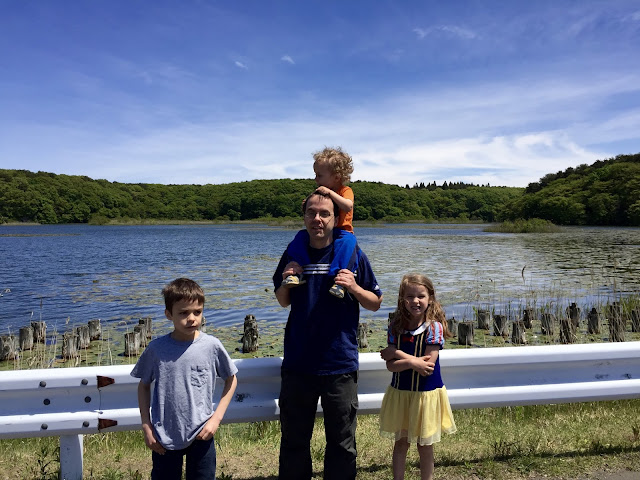
 Still not the best day for a swim, but the kids like wading around and looking at the minnows in the water. Eventually they fell in and the wet shirts came off.


This little park is apparently a rest stop for tourist buses. While we played, several buses pulled up so people could take pictures and use the nearby restroom. Apparently American children make for a great tourist attraction because after taking pictures of the lake, they all snapped a few pictures of our kids too. We should set up a booth. 100 Yen for a picture with an American kid. 200 yen for the one with blue eyes.


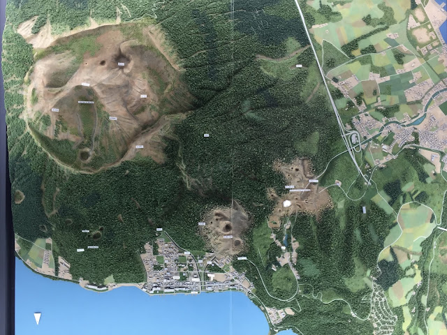
A satellite map of Mt Usu and Lake Toya on the floor of the Visitor Center


 This used to be a road


 A sign said this was a cookie factory that was destroyed. My face is smiling but I'm crying inside. Not the cookies!


Toya is a caldera lake located at the foot of Mt Usu - an active volcano. The most recent eruption occurred in 2000.

Our cute hotel

The street that our hotel was on


A view of the lake. The mountain on the right is the island in the middle of the lake, not the opposite shore. We also like to joke about those solar panels doing a lot of good in weather like this.

A sign with information on the eruption


A channel to guide the lava flows to the lake instead of through the town.

A path lined with beautiful hydrangea bushes.

After exploring for a bit, the drizzle seemed to be dissipating, so we headed for the lake.


The place where we stopped at the lake had a little park. We found this stature. Apparently, not only is Christ buried in Japan, but Noah also built the ark in Hokkaido. Who knew.


Once the rain started picking up, the kids changed clothes and we sought shelter inside the Volcano Science Museum.


A satellite map of Mt Usu and Lake Toya on the floor of the Visitor Center


Alivia swimming in the lake

A model of Mt. Usu and the surrounding craters

Our hotel was on this road by the pond. After we finished exploring the museum, we decided to brave the rain and hike the little trail to these smaller craters.

All bundled up


Steam venting out of this crater


I think the kids liked finding big snails anywhere, more than they cared about volcano craters
One of the steam vents was really close to the trail, but we couldn't get a good view of it. Seth hopped off the trail a bit and I kept walking with the kids (so they wouldn't want to off-road it with him). I admit, I was a little stressed while he was gone. Now that I see how close he actually got, it makes me feel very stressed. It is neat to see though.


These boys! <3 This is steeper than it looks, and slippery from the rain, so I wanted Caleb to hold my hand going down. He would only hold Simeon's hand. So cute!
It was time to say goodbye to Toya. We had a three hour drive ahead of us before we reached our next hotel. Driving out of town we were surprised to spot this view of Mt. Usu. I didn't realize it had this red, rocky top. Very cool.


Whoa, you guys are so lucky to have gotten to explore a place of such historical significance!! :P
ReplyDelete